Cold outbreaks remain a normal feature of winter circulation, even in a warming climate. Warming is a change in the background state: on average, cold extremes at the surface have become less frequent, but they are not eliminated.
Cold waves are part of basic atmospheric physics.
This winter, a prolonged period of cold weather affected the eastern United States, while much of the West was unusually mild and, in places, very dry. Snow fell in parts of Florida, and many daily minimum-temperature records were broken. Cold air also reached well into the subtropics and parts of the Caribbean. Last winter, New Orleans experienced a historic snowstorm, and parts of the Gulf Coast even saw blizzard conditions.
Such events are striking examples of how regional weather can behave in ways that might seem to contradict the global-average temperature trend.
Some have argued that these events are a consequence of a warming climate producing a “wavier” jet stream. But when we look at the observations and the dynamics of the atmosphere, a more straightforward and physically consistent explanation emerges — one that also helps explain why extreme cold outbreaks still occur in a warming world.
That explanation is the focus of this post.
The jet stream is a temperature contrast
The polar jet stream exists because between low and high latitudes there is a temperature difference in the troposphere — the lowest layer of the atmosphere, where all weather occurs. Higher latitudes are colder because they receive less solar heating, or none at all during part of the cold season. This temperature contrast across latitudes is smaller in summer and larger in winter.
One standard way meteorologists examine this structure is by looking at a standard level of the atmosphere at roughly the middle of the troposphere — technically, the height of the 500 hPa pressure surface, which typically falls about 18,000 feet above sea level. The actual altitude of this pressure surface varies: it sits ~5.7 km (19,000 ft) in warm air and drops to ~4.8 km (16,000 ft) in very cold air. When the lower atmosphere is cold and dense, this surface is found at a lower altitude. When the air is warm, it is higher.
In a figure showing pressure heights, like the two figures below, the spacing of the height contours shows wind speeds: tightly packed lines mean strong winds; widely spaced lines mean weaker winds. On these continental scales, winds blow parallel to the height contours.1
Typical winter structure
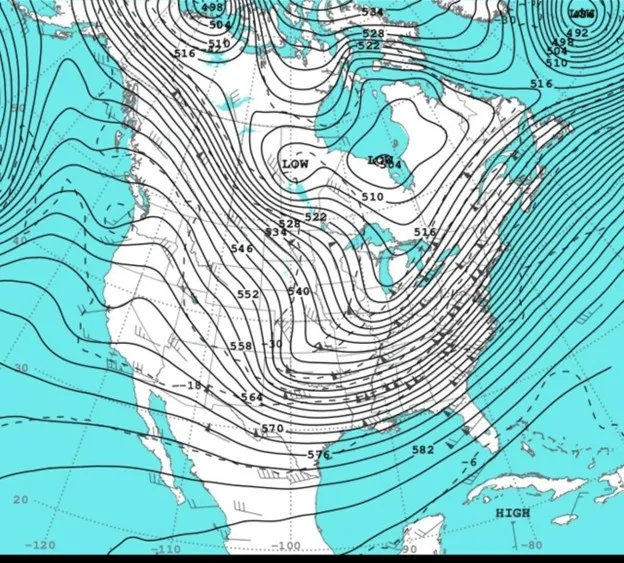
In winter (e.g., January 26, 2026 in the figure below, from National Weather Service), the height gradient between low and high latitudes is large. (The contour values are in tens of meters: for example, the label “570” corresponds to 5,700 meters or ~18,700 ft).
That is why the jet stream is typically strongest at this time of year. These figures show the elevation above sea level of the 500 hPa pressure level. The jet stream is strongest where the spacing between lines of is closest.
Typical summer structure
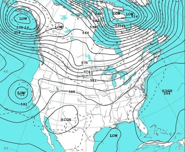
In summer (e.g., July 15, 2025 in the figure below, from NWS), the temperature contrast across latitudes weakens, the gradient relaxes, and the jet stream becomes much weaker.
These figures illustrate a key point: waviness exists in all seasons. What changes most is the size of the temperature contrast, and therefore the strength of the jet stream.
Winter storms are how the atmosphere reduces the contrast
The boundary at the surface between cold polar air and warmer mid-latitude air is called the polar front. Winter storms form along this boundary when the temperature difference becomes large enough that the jet stream changes from nearly zonal east-west flow into waves with a significant north-south orientation, producing extratropical cyclones — the large, rotating low pressure systems that drive winter weather across the mid-latitudes.
When these cyclones intensify, they transport warm air towards higher latitudes ahead of them and cold air to lower latitudes behind them. In other words, they act to reduce the temperature difference that created them.
The more intense the temperature gradient, the more energetic these storms can become — a process known as baroclinic instability, the technical term for when temperature contrasts between air masses drive storm development. The typical spacing between these weather systems — about 3,000 to 5,000 kilometers — is set by fundamental physics.
This winter’s outbreaks of Arctic air into the United States was associated with an intense winter cyclone and a large-scale circulation pattern favorable for East Coast storminess and frigid cold — perfectly consistent with what theory tells us should happen when the winter temperature contrast remains strong.
Very cold air still exists
The key issue therefore is not whether the global average surface temperature is increasing. The key issue for winter cold outbreaks is whether the high latitudes still produce very cold air in the troposphere, because that is what drives storminess.
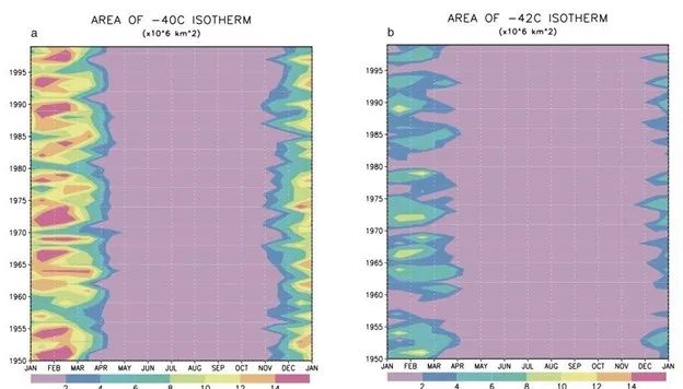
To explore trends in cold air in the troposphere, in a series of research papers we looked at temperatures at the 500 hPa level over many decades.
Here is what we found: The coldest tropospheric air masses, of similar intensity as in past decades, still form in the cold season, and the atmosphere maintains this reservoir of very cold air over high latitudes, each winter.
In our research, we found that the coldest tail of the 500 hPa temperature distribution appeared to change less than one might expect from global-mean warming alone, even though cold extremes at the surface overall have declined in many regions.
The figures below illustrate little change over the period 1950 to 1998 in the areal coverage of the coldest air. In a 2023 update of that analysis, we found little evidence of change in this pattern over 1980 to 2019.
One reason air does not get even colder later in the winter is that when extremely cold air flows over relatively warm, unfrozen ocean, strong convection and mixing of the atmosphere over the ocean limit further cooling.
Even as average global temperatures have increased, the reservoir of very cold air that fuels frigid and stormy winters has not disappeared, and atmospheric circulation continues to transport cold weather towards lower latitudes.
What this means for future winters
The strength of the jet stream is tied to the north-south temperature contrast. That contrast still becomes large early every winter, so the jet still strengthens seasonally. When the circulation sets up in the right way, intense mid-latitude cyclones and deep troughs can still drive polar air far equatorward.
This chain of cause and effect does not depend on global-mean temperature. It depends on the structure of the winter circulation and on whether very cold air still exists at high latitudes.
Observations indicate that this cold reservoir has not vanished. That is why severe cold outbreaks have not disappeared. They are still expected to occur well into the future because the tilt of the Earth means that winters at high latitudes will continue to get very cold with limited sunlight.